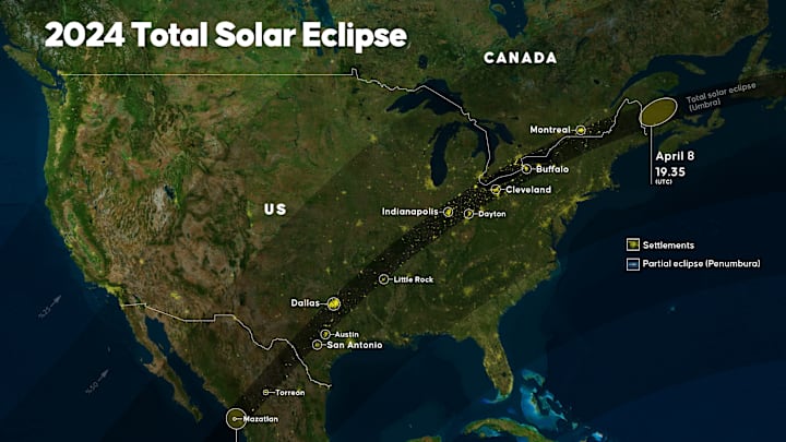
North America will be treated to a solar eclipse on Monday, April 8, 2024. This marks the second total solar eclipse to appear over the continent in less than 10 years—but it’s the last one in the contiguous U.S. until 2044. If you want to see the phenomenon under the best conditions possible, NASA has released an interactive map to help you plan your viewing experience.
To use the Eclipse Explorer on the space agency’s website, start by plugging in your zip code. The tool will tell you when the eclipse is starting and ending in your area, as well as the time of max coverage and what percentage of the sun will be blocked at its peak. A handy countdown clock shows you exactly how much time you have left until the sun and moon reach max overlap over your neighborhood. In addition to your geographic location, the weather is an important (and hard to predict) factor of your eclipse viewing experience. NASA’s Eclipse Explorer also pulls up the latest weather information for the selected zip code, so you can get an idea of what the skies outside will look like before viewing them through your safety glasses.
A solar eclipse happens anytime the moon appears to pass over the sun. To experience a total solar eclipse, you’ll need to wait until the moon fully covers our solar system’s star, resulting in up to four and a half minutes of surreal, daytime darkness. If you want to experience the rare event, you’ll need to find your way to the path of totality on April 8. The interactive map on NASA’s website makes this easy to do as well. As the map shows, many cities across the U.S. fall within the prime viewing path, including Austin and Dallas in Texas, Indianapolis in Indiana, Cleveland in Ohio, and Burlington in Vermont. Clicking on one of these locations shows you the local weather as well as the time and duration of totality.
Driving to the path of totality won’t do you much good if you can’t see the sun when you get there. Though cloud cover can be hard to predict until the day of, there are steps you can take to maximize your chance of clear skies. Visibility will likely be best at lower latitudes, like Mexico and Texas, and early forecasts so far back this up. If you go some place father North like New England, you’re more likely to encounter a gloomy April day. The best strategy is to have a flexible game plan, so you can check the weather up until the last minute and chase clear skies if needed.
If you plan on driving to witness the total solar eclipse on April 8, make sure you keep safety in mind. Traffic will be brutal throughout the path of totality, so give yourself plenty of travel time and don’t hit the road without water, snacks, chargers, and a full tank of gas. And whether you’ll be viewing a total eclipse or a partial one, your eyes need protection. Unless you’re using certified eclipse glasses, never look directly at the sun. Here are more safety tips to know ahead of the big event.
