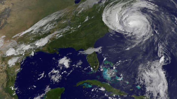
Autumn is the peak of hurricane season, also known as Cape Verde season, after the islands where the so-called "hurricane highway" originates. Here are seven facts about this awesome—and sometimes deadly—weather phenomenon.
1. The hurricane highway begins near the African coast.
The Cape Verde Islands, located off the northwest coast of Africa, are where the hurricane highway starts. Thunderstorms destined to become hurricanes often form into a tropical depression near the islands, slowly organizing and strengthening over the following week as the system moves toward the Caribbean. These storms have a long time to get their act together, but they also have to cover a lot of distance without losing their power to reach the East Coast as a hurricane. Some storms are able to thrive with little wind shear, ample warm water, and moist air, while others starve and dissipate if they encounter cooler waters and strong winds, or ingest dry, dusty air blowing off the Sahara Desert.
2. An easterly jet stream gives rise to the hurricane highway.
It’s hard to imagine from North America that a couple of thunderstorms on another continent thousands of miles away can swirl up into a monstrous storm, but it happens almost every year. The extreme temperature gradient between the blistering heat of the Sahara Desert and the more temperate climate of the savanna to its south creates an easterly jet stream that triggers clusters of showers and thunderstorms. These clouds then move from east to west, emerging off the western African coast near the Cape Verde Islands. Every year, the right conditions turn a handful of these localized storms into tropical storms that make their way across the Atlantic.
3. The biggest hurricanes start with the smallest storms on the hurricane highway.

Hurricanes, cyclones, typhoons—these are all names for the same force of nature, like Hurricane Andrew, which hit the East Coast in 1992. Cyclones like Andrew don’t just form out of thin air. All tropical cyclones require a relatively tiny “nucleus” of thunderstorms in order to develop. When the air and water temperatures are right, these groups of thunderstorms sometimes spin up into a fierce low-pressure system capable of causing a lot of damage. We see lots of these seedling thunderstorms over the ocean every year, but only a small number of them become hurricanes.
4. Hurricanes form in different places in different months.
Where a tropical storm or hurricane begins its trip across the ocean depends on what time of the year it forms. Storms that form early in the season usually get their start from thunderstorms or cold fronts that stall over the water very close to land; almost all of the storms that form in the Atlantic in June come to life within a few hundred miles of land. When we reach the peak of hurricane season, though, they start to form farther and farther out in the ocean—all the way out to the shores of Africa.
5. Fall is the peak of hurricane season on the hurricane highway.
Hurricane season in the Atlantic Ocean runs from June 1 through November 30. Storms are most common during that six-month stretch of the year, but sometimes they can form earlier or later too. That said, the period between the middle of August and the middle of October is typically the climatological peak of the season. That’s because, as the ocean water gets warmer, the atmosphere becomes conducive to vigorous storms, increasing the risk for hurricanes and tropical storms.
6. Cape Verde hurricanes can easily land in the record books.

Tropical waves traveling west from the coast of Africa in the middle of the summer are the culprits behind some of the worst hurricanes we’ve experienced in the United States. For example, on August 8, 2005, a small tropical wave emerged off the coast of Africa, soon becoming Tropical Depression 10. That depression would fall apart a few days later, but its remnants kept moving toward the U.S., redeveloping into a new tropical depression over the Bahamas on August 23. That new tropical depression became Hurricane Katrina, the costliest hurricane to ever strike the United States.
It’s a similar story for many—but not all—major hurricanes in recent history. Hurricanes Andrew, Dennis, Ivan, Isabel, and Ike were all Cape Verde–type storms that sprang to life thousands of miles away from where they would ultimately wreak havoc.
7. Strong hurricanes can still form in other places in autumn.
While the far eastern part of the Atlantic Ocean is a hotbed of activity this time of the year, it’s not the only place you need to watch if you live near the coast. Storms that form close to land can quickly spin themselves into catastrophe. Hurricane Sandy formed just south of Jamaica and hit New Jersey in a matter of days in 2012. A tropical depression that developed east of Florida on September 18, 2005, exploded into Hurricane Rita just three days later, with 180 mph winds—the most intense storm ever recorded in the Gulf of Mexico.
Meteorologists are currently predicting an above-average hurricane season in 2020. It may be worth preparing: NOAA suggests gathering a few key disaster supplies to have on hand, getting an insurance check-up, and locating the safest high ground.
