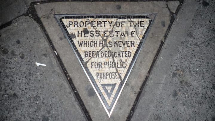
On an otherwise unremarkable stretch of sidewalk in New York City’s West Village, a tiny tile mosaic serves as David Hess’s century-old middle finger to City Hall. As cartoonist Chaz Hutton recently alerted us on Twitter, what was once the city’s tiniest piece of private property is the result of the angry collision of historic quirks in New York City’s street grid, turn-of-the-century city planning decisions, and intense grudge-holding. And you can still trespass on it today.
While most of New York City’s streets are laid out in a neatly ordered grid, Lower Manhattan—the oldest part of the city—is, cartographically speaking, kind of a mess. That’s because the city didn’t implement an official master plan for the layout of new streets until 1811, more than a century after the Dutch established a settlement at the southern tip of the island. The earliest-built parts of the city still maintain some of the quirks of a pre-plan settlement where property owners built their own streets with nearly no official oversight, resulting in a haphazard array of oddly shaped, variably sized blocks and narrow, crooked streets.
The bit of property now known as Hess’s triangle is located in this latter part of Manhattan, where the street grid is still a little wonky. It was even more so in the 1910s, when the city decided it needed to extend Seventh Avenue, a wide thoroughfare that was first built as part of that landmark 1811 master plan. In order to make room for traffic and for the construction of a new subway line, the city condemned an 11-block stretch of the West Village, demolishing hundreds of buildings starting in 1913. The extension was finished in 1916.

Because of the unique layout of the area, though, the new road didn’t cut through every block equally. Some property owners only lost only a corner of their buildings, while other structures were completely razed. Lots that were once full-sized became awkward triangles of property. Such was the case for Hess, who owned an apartment building called the Voorhis (or Voorhees, or Vorhes, depending on who you ask) that stood right in the middle of where the city wanted the road to run. Despite Hess’s best efforts to hold out, the city seized his property. Or, most of it. Though his building was demolished and the street built, the city’s surveyors accidentally missed a piece of it.
By 1922, Hess had already died, but his heirs weren’t about to give the city the land, no matter how useless it was. Instead, they laid down a mosaic of tiles inside the two-foot-wide triangle to serve as a reminder that it was private property, not just another stretch of sidewalk. It’s now known as Hess’s Triangle. The tiles read: “Property of the Hess estate which has never been dedicated for public purpose.”
The tiny plot—barely big enough for one person to stand on—is still there at 110 Seventh Avenue, sitting in front of what is now a cigar shop outside a subway entrance. You can even see it on Google Maps. It no longer belongs to the Hess estate, but it’s still private property—the Hess family sold it to the owner of the building next door in 1938.
[h/t Chaz Hutton]
