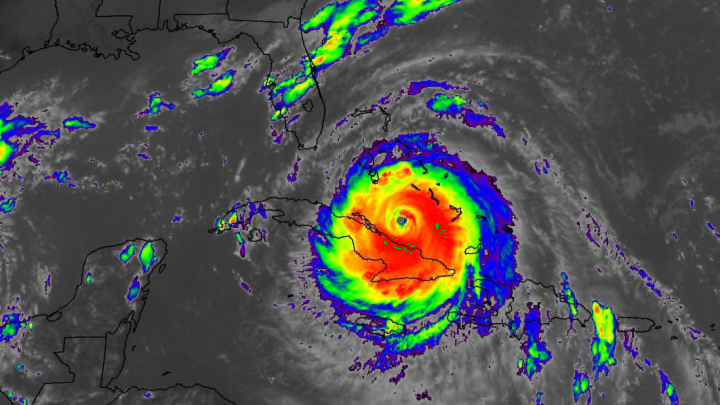
Florida is on alert ahead of Hurricane Irma's arrival this weekend. Residents across almost the entire state are evacuating and preparing for one of the worst storms to threaten in years. Hurricane Irma is still a high-end category 4 storm with destructive 155 mph winds. The storm has been remarkably resilient so far, maintaining its intensity for longer than just about any hurricane we've ever seen in the Atlantic Ocean. The storm will tear through parts of Cuba and the Bahamas before making landfall in southern Florida on Sunday. It's already knocked out power in Puerto Rico and savaged several Caribbean islands, including Barbuda, Antigua, and the U.S. Virgin Islands.
The latest advisory from the National Hurricane Center shows a hurricane that's been disrupted by its interaction with Cuba and smaller islands nearby, but they're not disrupting it enough to spare Florida from a very strong hurricane. The storm is still teetering on scale-topping category 5 intensity, and it's got plenty of very warm water to trudge through before it makes it to the United States. Meteorologists expect the storm to reach land on Sunday morning with maximum winds greater than 140 mph and slowly track up the entire length of the state before heading into Georgia and beyond.

This is a large hurricane that will have far-reaching impacts. Hurricane force winds currently extend 70 miles away from the center of the storm and tropical storm force winds extend 185 miles from the middle of the eye. Florida is only about 135 miles wide at its widest point, so this storm will easily engulf every part of the state outside of the panhandle. The greatest wind threat exists for the Florida Keys and communities that find themselves under the hurricane's northeastern eyewall. Although the worst conditions will depend on exactly where the hurricane makes landfall, the storm's sheer size ensures that the entire state will feel its full effects.
Irma's track up the entire state is unusual. Many hurricanes hit Florida's Atlantic or Gulf coasts and cross over land, exposing a smaller number of towns and people to strong winds. This hurricane will do what we feared Hurricane Matthew would do last year, but luckily didn't; by following the entire length of the peninsula, Irma will expose tens of millions of people to potentially life-threatening weather conditions in the 36 hours following landfall.
The storm's impacts aren't limited to Florida. Irma will slowly weaken as it travels up the Florida peninsula, but it will still produce strong winds and heavy rain across Georgia, the Carolinas, and parts of the interior southeast through early next week. Heavy rain could lead to flash flooding in some low-lying areas, and the rain will soften the soil and make it easier for winds to topple trees and power lines.
Hurricane Irma has been a weather forecasting success story. We've been following the wave that would become Irma since the middle of August, before it even emerged off the coast of Africa. The storm quickly cranked up in the eastern Atlantic, and we've watched it steadily make its way toward the United States over the past two weeks. Residents in the path of the storm have had ample time to prepare, and it seems to be paying off.
Highways started filling up with evacuees earlier this week, and just about everything is closed. Walt Disney World will close its parks early on Saturday and remain closed on Sunday and Monday—something that's happened fewer than a dozen times in the resort's five decades in operation. Most flights to and from Florida airports will be cancelled ahead of the storm. All schools in the state are closed through Monday.
The preparations leading up to this storm are proof that weather forecasting has made huge improvements over the past couple of decades, and that people in the path of the storm are actually heeding the warnings. The long lead-up to this storm will hopefully limit the number of people hurt once it makes landfall, which is always the ultimate goal of forecasting disasters as great as Hurricane Irma.
