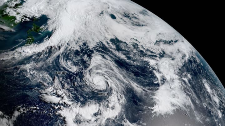
What happens when two hurricanes start to invade each other's personal space? It's easy to picture the two hurricanes merging into one megastorm that tears across the ocean with twice the fury of a normal storm, but what really happens is less dramatic (although it is a beautiful sight to spy on with satellites). Two cyclones that get too close to one another start to feel the pull of a force called the Fujiwhara Effect, a term that's all the rage in weather news these days.
The Fujiwhara Effect occurs when two cyclones track close enough to each other that the storms begin orbiting around one another. The counterclockwise winds spiraling around each cyclone force them to participate in what amounts to the world's largest game of Ring Around the Rosie. The effect is named after Sakuhai Fujiwhara, a meteorologist who studied this phenomenon back in the early 1900s.
The extent to which storms are affected by the Fujiwhara Effect depends on the strength and size of each system. The effect will be more pronounced in storms of equal size and strength; when a large and small storm get too close, the bigger storm takes over and sometimes even absorbs its lesser counterpart. The effect can have a major impact on track forecasts for each cyclone. The future of a storm completely depends on its new track and the environment it suddenly finds itself swirling into once the storms break up and go their separate ways.
We've seen some pretty incredible examples of the Fujiwhara Effect over the years. Hurricane Sandy's unusual track was in large part the result of the Fujiwhara Effect; the hurricane was pulled west into New Jersey by a low-pressure system over the southeastern United States. The process is especially common in the northwestern Pacific Ocean, where typhoons fire up in rapid succession during the warmer months. We saw a great example of the effect just this summer when two tropical cyclones interacted with each other a few thousand miles off the coast of Japan.
Weather Channel meteorologist Stu Ostro pulled a fantastic animated loop of two tropical cyclones named Noru and Kulap swirling around each other at the end of July 2017 a few thousand miles off the coast of Japan.
Typhoon Noru was a small but powerful storm that formed at about the same latitude as Kulap, a larger but much weaker storm off to Noru's east. While both storms were moving west in the general direction of Japan, Kulap moved much faster than Noru and eventually caught up with the latter storm. The Fujiwhara Effect caused Typhoon Noru to stop dead in its tracks, completely reverse its course and eventually perform a giant loop over the ocean. Typhoon Noru quickly strengthened and became the dominant cyclone; the storm absorbed Kulap and went on to become a super typhoon with maximum winds equivalent to a category 5 hurricane.
