Hurricanes are a terrifying display of nature's power. Even last century, a perfectly sunny day could turn into unimaginable horror without any warning at all, as storms leveled entire towns and upended thousands of lives. We've come a long way since those dark days, and now we can watch hurricanes churn over the ocean in weather broadcasts in time to get out of the way. One of the best ways we can follow these storms is thanks to the men and women who make up the so-called (yes, actually) Hurricane Hunters.
The Hurricane Hunters are scientists working for both NOAA and the United States Air Force who fly airplanes into the worst parts of a hurricane to tell us first-hand what the storm is doing. Bad-ass scientists began regularly flying into storms (on purpose) after World War II, and today the practice is a standard part of hurricane forecasting in the United States. If satellite and radar imagery of a storm are like doctors taking an x-ray of your body, the work of the Hurricane Hunters is like drawing blood, sampling the inside of the storm to get a good idea of what it's doing at the moment.
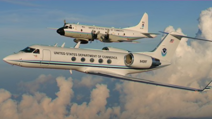
NOAA's two famous Hurricane Hunter aircraft are Lockheed WP-3D Orions—nicknamed "Miss Piggy" and "Kermit"—that are equipped with special sensors and devices that help the meteorologists look at the storm and understand what makes it tick. The U.S. Air Force's 53rd Weather Reconnaissance Squadron also operates a fleet of 10 WC-130J Hercules aircraft that utilize similar equipment when they fly out into storms.

All of the aircraft are equipped with Doppler weather radar that helps both the airplane crew and meteorologists back on dry ground understand the internal structure of a storm. This radar imagery is useful for seeing the structure of the eyewall—important for determining its strength and longevity—as well as information about rain bands and any intrusions of dry air that could affect the storm's future.
The most important feature of all Hurricane Hunter aircraft is dropsondes, or small tubes filled with weather sensors that are dropped from the aircraft into the storm. Dropsondes work on the same principle as weather balloons, but the sensors go in the opposite direction—up to down. These sensor packages measure conditions like temperature, dew point (moisture), and air pressure, while GPS sensors help determine wind speed and direction. This information is relayed back to the crew in real-time. Dropsondes help meteorologists measure the lowest surface air pressure within the eye of a storm as well as the highest wind speeds in the storm.
One of the most innovative tools the Hurricane Hunters use is a piece of technological wizardry known as a Stepped-Frequency Microwave Radiometer, or SFMR. The SFMR is a device attached to the wing of the aircraft that monitors the amount of microwave radiation being reflected beneath the plane by factors like waves, sea foam, and rainfall rates. Meteorologists are able to use data collected by the SFMR to accurately estimate the wind speed beneath the aircraft. In fact, the National Hurricane Center was able to use data collected by an SFMR on one of the Air Force's planes to determine that Hurricane Patricia's peak winds reached a record-breaking 215 mph [PDF] off the western coast of Mexico in October 2015, which is the highest wind speed ever recorded in a tropical cyclone anywhere in the world.
NOAA also uses a Gulfstream IV-SP aircraft to survey the environments around and ahead of tropical cyclones as they draw closer to land. These aircraft fly at high altitudes and release dropsondes to measure both moisture and wind speed and direction to help meteorologists better understand the environment into which the storm is heading. This data, along with more frequent weather balloon releases on land, can be ingested into weather models to help forecasters create more accurate predictions for the eventual track a tropical storm or hurricane will take—and help keep you safe.
