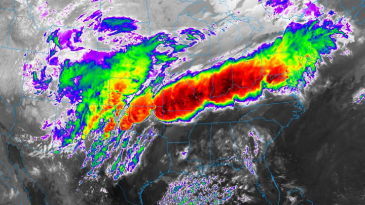
An active month for severe weather went out with a bang this weekend when waves of powerful thunderstorms slammed the central United States, causing widespread flooding across the Midwest and several destructive tornadoes in Texas. The storm was so large and dynamic that it even caused a historic blizzard in western Kansas. The system responsible for the damage may be out of the picture now, but the dangerous effects of the tropical downpours will linger through next weekend.
A large, pinwheeling low-pressure system developed over the Plains late on Friday, April 28, 2017, setting the stage for a rambunctious couple of days in the American heartland. Counterclockwise winds flowing around the low-pressure system dragged deep plumes of tropical moisture northward from the Gulf of Mexico, allowing a warm, muggy air mass to crash into a cooler air mass lingering over states like Missouri, Illinois, and Indiana. The leading edge of this muggy air—a warm front—served as the focus for explosive thunderstorm development on Friday night and Saturday.

Unlike most organized batches of thunderstorms, which typically rage over one area for a few hours before moving on or dissipating, these torrents stuck around for almost an entire day, dumping copious amounts of rain over the Ohio and Mississippi River valleys as they rode along the boundary between warm to the south and cool to the north. This phenomenon, known as “training” due to thunderstorms rolling over the same areas like train cars on railroad tracks, is typically responsible for the worst flash flooding that storms can produce. Some communities recorded more than 10 inches of rain in just one day, which is more than double the normal amount of rain these areas see on average during the entire month of April.
At least 10 people died due to flooding across the Midwest, according to a report by The Weather Channel, and countless more residents were rescued from homes and vehicles when the water rose too quickly for them to evacuate on their own. Almost all of the confirmed flooding deaths this past weekend occurred in vehicles; the National Weather Service notes that nearly half of all flash flood deaths that occur every year are the result of people drowning in their vehicles.
The flooding isn’t over yet. Rivers in the region will continue to rise as the slow runoff overwhelms area waterways. At least two dozen gauges that measure water height in rivers across the areas affected by the heavy rain reported major flooding on Sunday, April 30, with numerous rivers expecting near-record flooding through the end of the week. The Mississippi River at Cape Girardeau, Missouri, is expected to crest at 48.5 feet on Friday, May 5, just shy of the all-time record high water mark set at this location in 2016 and a little bit above the historic and devastating flooding measured in 1993. The Mississippi River in St. Louis, Missouri, will likely reach major flood stage on Wednesday, May 3, though the crest will fall nearly 10 feet short of the record set back in 1993.
Flooding wasn’t the only concern with the storms this weekend. Meteorologists confirmed on Sunday that three tornadoes swept through the town of Canton, Texas, on Saturday evening, killing at least four people and injuring dozens more as the twisters caused significant damage.
Canton, a small town about 55 miles east of Dallas, Texas, saw all three tornadoes in the span of one hour, which is extremely rare but can happen from time to time. The first tornado hit the western side of town, while the second tornado struck the eastern side of town less than an hour later. A smaller tornado touched down just north of Canton in between the tracks of the two larger tornadoes.
The National Weather Service rated the first Canton tornado a violent EF-4, the second-highest level on the Enhanced Fujita Scale, while the second tornado received an EF-3 rating. Survey crews found that three additional tornadoes touched down in the area, including the one that struck the north side of Canton. All three small tornadoes produced minor damage and received the lowest rating, an EF-0.

The eastern side of the storm may have seen a classic springtime severe weather outbreak, but the western side of the system didn’t quite get the memo that it’s the end of April. Portions of the Rocky Mountains and western Plains saw a significant snowstorm this past weekend. A large swath of western Kansas saw more than a foot of snow, with some areas coming close to 20 inches by the time the skies cleared out. This snowstorm ranks among the largest snowstorms ever recorded in western Kansas during the month of April, and could easily be the biggest snowstorm ever recorded so late in the year across areas that should see supercells instead of snow squalls.
