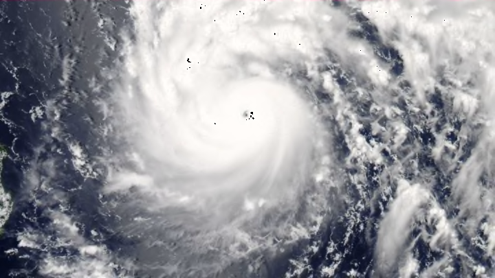
Taiwan endured the impact of ferocious Typhoon Nepartak this month, a storm that crashed ashore with winds equivalent to those of a category four hurricane. The island nation, which sits off the southeastern coast of China, is a regular target for major tropical cyclones, Nepartak being the second such intense storm to come ashore there within the past year. The eastern Pacific Ocean is also hopping this summer, producing one tropical cyclone every couple of days so far this month. Meanwhile, the Atlantic has been dead quiet. This is a common pattern during the summer, and it raises a natural question: Why are hurricanes and typhoons more common in the Pacific Ocean than the Atlantic Ocean?
Tropical cyclones go by many names around the world, and the terminology can get confusing. Once a tropical cyclone strengthens to the point where it has gale-force winds—39 mph or greater—it becomes a tropical storm. A storm that reaches tropical storm strength usually gets its own name to help us quickly identify it in forecasts and warnings.
Once a tropical storm begins producing sustained winds of around 75 mph, we call the storm a typhoon in the western Pacific near Asia and a hurricane in the oceans on either side of North America. A “typhoon” and a “hurricane” are the same kind of storm, they just go by different names.
The Atlantic Ocean sees its fair share of named storms each year, averaging around 11 named storms in a normal season. The eastern Pacific Ocean averages around 16 named storms every year, and the western Pacific churns out more than two dozen named storms in a normal year. There are several factors that contribute to the Pacific teeming with cyclones while the Atlantic can sometimes struggle to see rogue thunderstorms let alone anything more ominous.
THE PACIFIC IS WARMER
Sea surface temperatures (°C) around the world on July 14, 2016. Image credit: NOAA/ESRL/PSD
Warm sea surface water is the fuel that drives tropical cyclones. If you ignore large-scale anomalies like El Niño and La Niña, the waters in the Pacific Ocean are usually warmer than those of the Atlantic Ocean, and the temperatures stay pretty toasty through almost the entire year. If you were to take a swim in the water off the coast of the northern Philippines, it would feel like you dunked yourself into a freshly drawn bath, just as it would if you took a dip in the ocean at a beach in Florida. Though parts of the Atlantic get uncomfortably warm, the expanse of hot water is much larger in the Pacific than it is in the Atlantic. The larger pool of steamy water gives more disturbances the opportunity to spin-up into major storms.
The persistent warmth of the western Pacific allows the typhoon season there to last the entire year, unlike around North America where it starts in May in the eastern Pacific and June in the Atlantic, both stretching through November. In addition to ocean currents, which have a major impact on sea surface temperatures, another significant factor in the Atlantic’s relative coolness is its proximity to land.
THE LAND IS A GOOD DEFENSE
Deep cold fronts don’t stop at the beach when they’re finished sweeping across the United States and Canada. Some cold fronts can keep sailing long after they leave shore, traveling across vast swaths of the ocean and dipping as far south as the islands of the Lesser Antilles. The constant train of cold fronts marching out to sea during the early spring and late fall can put the kibosh on tropical cyclone formation, stabilizing and drying out the air and chilling the warm sea surface waters. The Pacific doesn’t have that common issue—most storms stay far enough north that they don’t much affect the typhoon and hurricane seasons across the basin.
Saharan dust crossing the Atlantic Ocean in June 2010. The image was stitched together from a series of images collected by the Moderate Resolution Imaging Spectroradiometer (MODIS) on NASA’s Terra satellite during successive orbits; gray areas show gaps between satellite overpasses. Image credit: NASA Earth Observatory
Dry air is also a major problem in the Atlantic Ocean. The Saharan Air Layer (SAL) recently made the news as dust blowing off Africa’s Sahara Desert traveled across the entire ocean and made for some hazy, colorful sunsets in the southeastern United States. These puffs of dry, dusty air coming off Africa don’t only alter our sunsets, but they can have a big effect on tropical cyclones. Dry air is the arch nemesis of tropical cyclones; by their very nature, these cyclones need as much moist air as they can ingest to survive and thrive during their life cycle. Dry air that spirals into the center of a tropical cyclone can collapse the thunderstorms and cause the storm to fizzle out.
Thunderstorms that develop over Africa also serve as the nucleus for some of the worst storms the Atlantic can produce. Disturbances that drift off the African coast can quickly come to life near the Cape Verde Islands, gaining steam as they spiral west toward North America. If western Africa experiences a drought (or the SAL keeps blowing west), it can have a significant impact on the Atlantic hurricane season.
The ironic thing about tropical cyclones is that they produce some of the worst winds on Earth, yet relatively weak winds in the atmosphere can force them to dissipate. Atmospheric wind shear—strong winds that change speed and direction with height—is a death sentence to budding tropical storms. Winds blow the tops off the thunderstorms and prevent them from developing into much more than a brief pulse. Wind shear is also much greater in the tropical Atlantic than it is in the tropical Pacific, both due to regular jet stream patterns and the constant stream of low-pressure systems blowing off North America.
