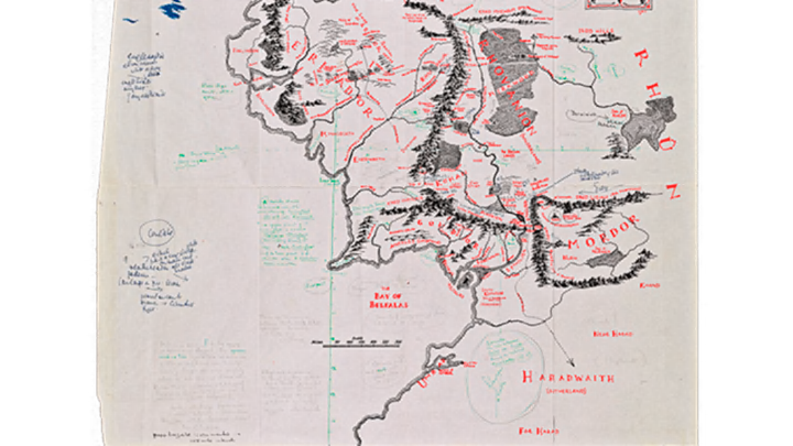
Rare Tolkien Map Will Be on View to the Public for Just One Day

J.R.R. Tolkien was a stickler for cartography related to Middle-earth, so when illustrator Pauline Baynes was commissioned to create a poster of the author’s detailed fantasy world, he was determined to make sure she represented his mental map accurately.
A recently discovered map annotated by the author for Baynes now belongs to the Bodleian Libraries at Oxford, and it will be on view to the public for one day this month, Smithsonian reports. On June 23, you can catch a live glimpse of it from 9:30 a.m. to 5 p.m. in Oxford.
The map, pulled out of a volume of The Lord of the Rings, is full of Tolkien’s scribbles in green ink and pencil, showing Middle-earth locations and climates in relation to their real-life latitude (Hobbiton was at about the same latitude as Oxford) and Elvish names of places not mentioned in the books themselves. The fastidious author went so far as to specify the colors the ships should be and where different animals should appear. The original map of Middle-earth that appeared in the books in 1954 was drawn by Tolkien’s son, Christopher.
Pauline Baynes's 1970 poster map. ©HarperCollins Publishers Ltd 1970.
Baynes, who also illustrated all of C.S. Lewis’s Chronicles of Narnia, was the only artist Tolkien would approve to illustrate his books while he was alive. She kept the annotated sheet until her death in 2008, and it went largely unknown to the public until 2015, when a rare bookstore put it up for sale and the Bodleian Libraries purchased it.
[h/t Smithsonian]