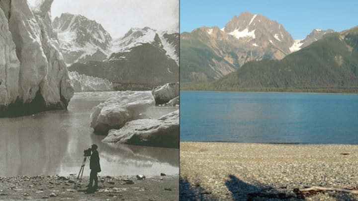
Whether it's a selfie-a-day project or the time machine function on Google Street View, few things are as effective at illustrating change over time as photography. NASA's Images of Change online gallery pairs photos taken of various places on Earth with historical images of the same locations to show how things like climate change, natural disasters, and urban growth have altered the landscape of the planet. Some of the images were taken a century apart, while others show drastic changes over a much shorter period of time.
As NASA notes, the images underscore how mutable Earth's surface really is. There are 309 sets of photos, including shots of growing urban sprawl in Cancun, Mexico, the shrinking ice caps of Iceland, and the damaged marshlands surrounding a post-Katrina New Orleans. Check out a few selections below, and head over to the NASA Global Climate Change website to view the full gallery.
Left: McCarty Glacier Melt, Alaska. 1909. Right: 2004. Images courtesy of Glacier Photograph Collection, National Snow and Ice Data Center/World Data Center for Glaciology.
Left: Urban growth, Mexico, 1979. Right: 2009. Images courtesy of the United Nations Environment Programme (UNEP)
Left: Drought, California, 2011. Middle: 2013. Right: 2014. Images courtesy of the U.S. Geological Survey (USGS) Landsat Missions Gallery / USGS and NASA.
Left: Drying Lake Urmia, Iran, 2000. Middle: 2010. Right: 2014. Images courtesy of the U.S. Geological Survey (USGS) Landsat Missions Gallery / USGS and NASA.
Left: Shrinking ice cap, Iceland, 1986. Right: 2014. Images courtesy of the NASA Earth Observatory
Left: Agricultural growth, Egypt, 1972. Right: 2003. Images courtesy of Earthshots: Satellite Images of Environmental Change
[h/t Architecture and Design]
